THE vision

Engineering India’s Aerial Intelligence Frontier

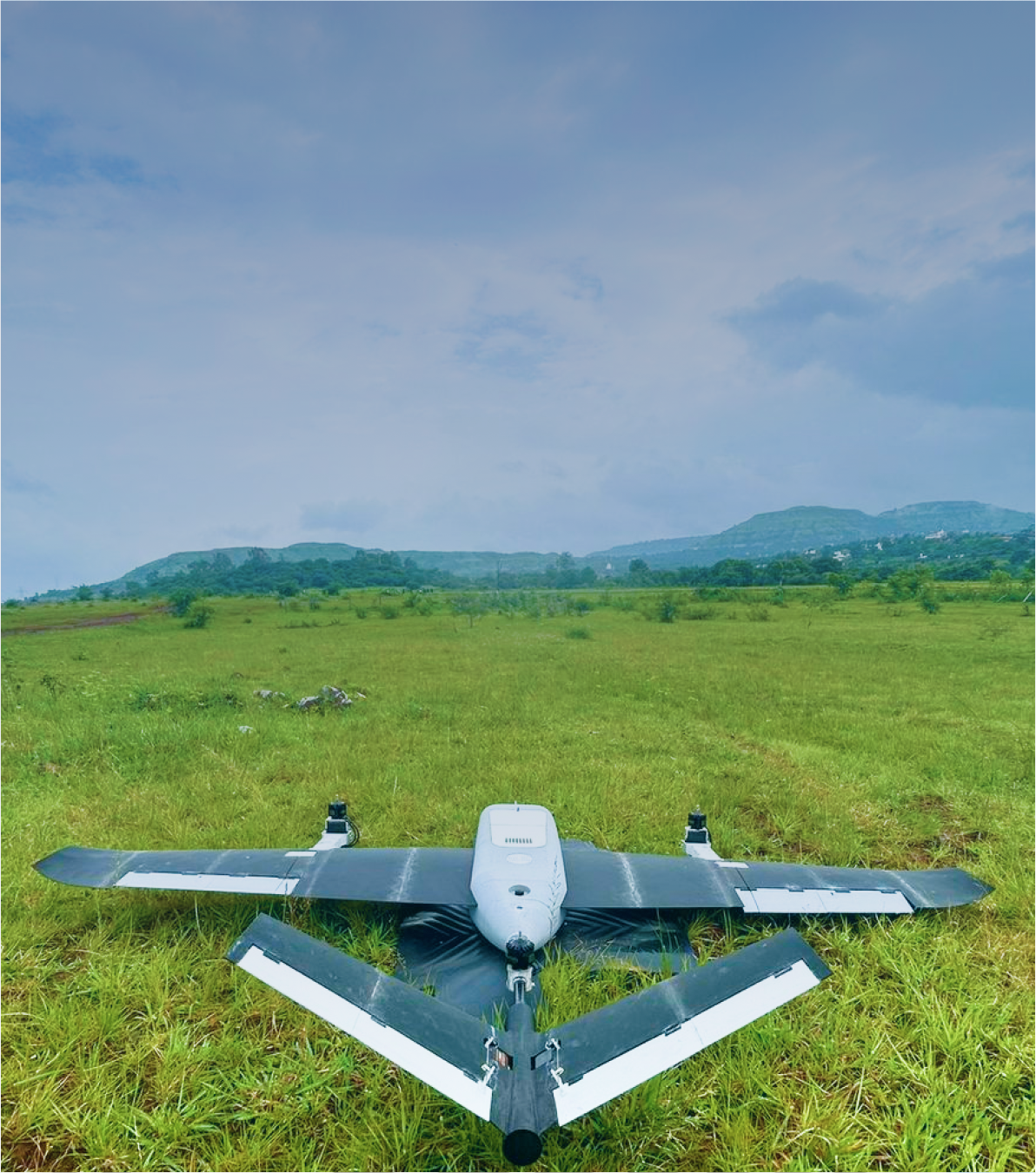
SurveyX is pioneering India’s indigenous VTOL drone ecosystem — delivering high-performance aerial platforms for defence, mapping, and infrastructure intelligence. With every airframe and circuit designed locally, we aim to put Indian innovation at the heart of global aerial intelligence.

SURVEYX 1600
Logo IpsumLogo IpsumLogo IpsumLogo IpsumLogo IpsumLogo IpsumLogo IpsumLogo Ipsum
Logo IpsumLogo Ipsum

We’re honored to partner with visionary clients who challenge us to innovate and excel.

SURVEYX 1600

Meet SurveyX 1600 — Precision from the Sky

120-minute endurance

Bringing innovative and imaginative designs to life with unique flair.

Compact, field-deployabledesign

Customizing designs to perfectly align with client needs and goals.

DGCA certification-ready

Implementing energy-efficient and eco-friendly solutions in each project.

AI analytics integration

Implementing energy-efficient and eco-friendly solutions in each project.

Fully indigenous components

EXPLORE SPECIFICATIONS
SURVEYX 1600

Key Points That Define Our Success

Get In Touch
Get In Touch
50+
Projects Completed

Successfully completed over 50+ projects across residential, commercial, and public sectors, showcasing our diverse expertise.

147
Skilled Professionals

Our team consists of 147 skilled architects, designers, and engineers, dedicated to delivering high-quality, innovative solutions.

$1.2B
Projects Value

Managed projects with a combined value of over $1.2 billion, demonstrating our capacity to handle high-budget, complex designs.

OUR SOLUTIONS

EXPLORE OUR SOLUTIONS

Mission-Ready Platforms for Modern Warfare

Designed for border surveillance, tactical reconnaissance, and ISR missions, SurveyX platforms deliver real-time intelligence with exceptional range, endurance,

Border & tactical ISR
Urban planning and smart city projects
Agriculture and forestry management
Mining, infrastructure, and renewable energy

Empowering the Future of Survey & Mapping

SurveyX 1600 enables precision-driven mapping and data intelligence for government and commercial missions — from Swamitva Yojana and LAM to Smart Cities and infrastructure mapping.

Land & cadastral mapping
Urban planning and smart city projects
Agriculture and forestry management
Mining, infrastructure, and renewable energy
SURVEYX 1600

EXPLORE OUR SOLUTIONS

Mission-Ready Platforms for Modern Warfare

Designed for border surveillance, tactical reconnaissance, and ISR missions, SurveyX platforms deliver real-time intelligence with exceptional range, endurance, and stealth.

Border & tactical ISR
Counter-insurgency & perimeter patrol
Disaster and search operations
Secure AI analytics and edge intelligence
COLLABORATIONS & RECOGNITIONS

Aligned with India’s Growth Mission

iDEX & MeitY grant applications under review
Eligibility under PLI Scheme for Drones
Engagement with Survey of India and Geospatial Ministries
Registered on GeM Portal for government procurement